


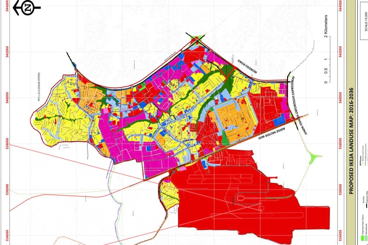
In 2016, the Lagos State Government, under the administration of Governor Akinwunmi Ambode, began reviewing the Ìkẹjà Model City Plan, which became operative in 2010.
The following year, in February 2017, the then Commissioner for Physical Planning and Urban Development, Architect Abiola Anifowoshe, presented the final draft of the revised plan to stakeholders and members of the public.
The review formed part of the state government’s broader effort to develop strategic master plans for Lagos, as outlined in the Lagos State Development Plan (2012–2025).
At the time, the government was pursuing development plans for several parts of the state, including Lekki, Badagry, Ikoyi-Victoria Island, Apapa, Lagos Mainland, Alimosho and Agege, alongside Ìkẹjà.
However, aside from being the state’s administrative capital, Ìkẹjà is also a hub for commerce, manufacturing, transport and residential life, making the Ìkẹjà Model City Plan first among equals.
To guide the city’s development, the revised Ìkẹjà Model City Plan sets out a 20-year framework covering the period from 2016 to 2036. The plan builds on the original document, which covered 2010 to 2020, and proposes how land use, roads, public transport, water supply, sanitation, population, commercial activities and public spaces should be organised as the city grows.
From improving road connections and public transport to planning commercial districts and green spaces, the revised document outlines a vision for a more organised and accessible Ìkẹjà.
In this Q&A, Ìkẹjà Record examines why the original plan was revised, the key development areas the plan addresses, how the plan is to be implemented and which of the planned projects have been executed so far.
Why was the original plan reviewed?
Which development areas did the plan address?
Roads and traffic management
Public transport and movement around the city
Land use and urban regeneration
Water supply and basic infrastructure
Drainage, sanitation and waste management
Commercial development and informal businesses
Green spaces and social infrastructure
How is the plan supposed to be implemented?
How much of the plan has been implemented so far?
Opebi-Ojota link bridge: Built, but not yet fully accessible
Olusosun landfill: A different approach to waste management
Public parks: New recreational spaces and renovations
Why was the original plan reviewed?
The revised plan identifies several reasons for reviewing the 2010–2020 framework.
One reason was the need to assess how the land-use proposals in the earlier plan had improved development in Ìkẹjà.
The review also sought to identify areas requiring more detailed planning, harmonise planning regulations affecting federal and state land as well as private estates, encourage public-private partnerships and generate a physical-planning database for research and public use.
According to the model plan document, the review was guided by the Lagos State Urban and Regional Planning and Development Law 2010.
Which development areas did the plan address?
The revised Ìkẹjà Model City Plan sets out proposals for how the city’s land, infrastructure and public facilities should be developed and managed.
Its recommendations cover issues ranging from road connectivity and public transport to water supply, waste management, commercial development and public spaces.
Roads and traffic management
Roads are central to the plan’s approach to urban development. It proposes improvements to the road network, including new links, bridges and junction upgrades intended to improve connectivity and reduce traffic bottlenecks.
Among the projects listed in the document’s early implementation phase was an Opebi–Ojota–Maryland link bridge.
Other proposals included an overpass at the Obafemi Awolowo Way and Allen junction, a link bridge around Omole connecting through Adeyemo Akapo to the Lagos–Ibadan Expressway, and additional road links around areas including Ogba-Isheri and Onilekere.
The document also identifies roads such as Wempco Road, Acme Road, Isaac John Street, Oba Akran Avenue, Jobi Fele Way and Joel Ogunaike Street for upgrading.
These proposals reflect the plan’s emphasis on improving connections between neighbourhoods and major routes. Better road links, in the framework’s vision, would support movement across the city and help accommodate its growing residential and commercial activities.
The plan also divides road development into phases. It places key primary roads in the 2016–2020 period, the remainder of the primary network in 2020–2025, and the secondary road network in the 2025–2036 phase.
These are the timelines stated in the revised document, rather than confirmation that every listed project was completed within those periods.
Public transport and movement around the city
The plan’s transportation proposals extend beyond roads for private cars. It advocates an integrated transport system that includes buses, bus rapid transit (BRT), rail, ferries and facilities for people travelling on foot or by bicycle.
The document refers to a proposed BRT lane from Berger to Tafawa Balewa Square and the planned Red Line rail route from Agbado to Marina. It also identifies walking and cycling routes as part of the broader transport framework.
The goal is to connect different modes of transport and improve access across the city. Walking and cycling routes would also offer more protection for pedestrians and people with disabilities.
Land use and urban regeneration
Another major part of the plan concerns how land should be used.
Residential neighbourhoods, offices, factories, markets and other commercial activities all require space. Where these uses are poorly coordinated, they can compete with one another and place additional pressure on roads, parking and public infrastructure.
The revised plan proposes clearer land-use arrangements and identifies opportunities for urban regeneration. It also recommends areas for higher-density development, high streets and mixed-use corridors.
Mixed-use development allows different activities, such as shops, offices and housing, to exist within the same area or development. High streets are intended to accommodate commercial activity along designated corridors, while higher-density development can make more efficient use of limited urban land.
The document’s approach is to organise growth rather than allow development to occur without a coordinated framework. It also calls for attention to existing development patterns and the preparation of more detailed plans for areas requiring additional intervention.
Water supply and basic infrastructure
A growing city needs infrastructure that can support its residents and businesses. The plan therefore includes proposals to improve water supply and other services needed for urban development.
Its water-supply recommendations include upgrading two existing mini-water works to a stated maximum capacity of three million gallons per day each, as well as providing two additional mini-water works with proposed capacities of 0.3 million and 1.3 million gallons per day.
These figures are proposals contained in the revised plan. They should be understood as part of its infrastructure design, rather than evidence of current water production or supply.
The broader idea is that physical development should be accompanied by adequate services. Roads and new buildings alone cannot support a functioning city if the water and other infrastructure needed by residents, businesses and institutions are insufficient.
Drainage, sanitation and waste management
The plan also addresses environmental infrastructure, including drainage and waste management.
It identifies the need for primary, secondary and tertiary drainage networks. These different levels of drainage infrastructure are intended to form a connected system for carrying water away from built-up areas.
The document also proposes adapting the Olusosun landfill into an integrated engineered sanitary landfill. This is a proposal in the plan, not a statement about the site’s present condition or operations.
These recommendations form part of the plan’s broader emphasis on an organised urban environment. Drainage and waste management are essential elements of city planning because they affect public health, environmental conditions and the usability of residential and commercial areas.
Commercial development and informal businesses
Ìkẹjà’s economic activities are another focus of the revised plan. The document proposes the creation of economic activity centres across five sectors of the model city, the revitalisation of the central business district and the development of shopping complexes at three locations.
It also proposes mixed-use corridors intended to accommodate more commercial activity and improve access to retail outlets.
The plan recognises that informal businesses are an important part of the local economy, even as their locations can create planning challenges. It proposes designating five locations as informal-sector enclaves and integrating informal economic activity more effectively into the city’s development framework.
For formal businesses, the document recommends measures such as improving infrastructure around industrial areas, streamlining the collection of taxes and charges, and considering tax incentives for manufacturing companies capable of creating substantial employment.
Taken together, these proposals seek to make Ìkẹjà more attractive to investors and businesses while providing a more organised framework for commercial activity.
Green spaces and social infrastructure
The plan’s vision also includes the development of public spaces and facilities that contribute to the quality of urban life.
According to the document, it is imperative to identify green areas for conservation, public open spaces, pedestrian and cycling routes, and ways to incorporate the needs of people with disabilities into the plan.
How is the plan supposed to be implemented?
The revised plan identifies several government bodies whose responsibilities relate to its proposals, including ministries responsible for physical planning, works and infrastructure, transportation, environment, health, and commerce and tourism.
Local governments, local council development areas, private organisations and communities are also relevant to the planning process.
The document envisages a role for private investment and public-private partnerships in physical development. For example, it discusses the possibility of private financing for parts of the proposed road network, alongside arrangements intended to involve affected communities and businesses.
It also notes that a proposed Model City Development Authority had not been implemented at the time the document was prepared. It therefore envisaged implementation through existing ministries, departments and agencies.
How much of the plan’s proposals have been implemented so far?
The revised Ìkẹjà Model City Plan sets out a long-term vision for the city, with proposed projects assigned to different implementation periods. But what can be established about some of these proposals today?
Three examples, the Opebi–Ojota link bridge, creation of public parks and the redevelopment of the Olusosun landfill offer a glimpse of how infrastructure plans have intersected with later government projects.
Opebi–Ojota link bridge: Built, but not yet fully accessible
The revised plan included an Opebi–Ojota–Maryland link bridge among its proposed road connections, intended to improve movement between neighbourhoods and reduce pressure on existing routes.
The Lagos State Government later constructed the Opebi–Ojota link bridge, which was commissioned on April 8, 2026. However, commissioning did not immediately translate into full public access.
In September 2026, Governor Babajide Sanwo-Olu said contractors were completing outstanding work and had assured the government that the bridge would be ready within two weeks. By October 10, Ìkẹjà Record reported that the bridge remained inaccessible to motorists, leaving commuters to continue using alternative routes.
Although the bridge corresponds to a connection envisaged in the model plan, its construction alone does not establish that the wider road network proposed in the document has been completed.
Olusosun landfill: A different approach to waste management
The revised Ìkẹjà Model City Plan proposed adapting the Olusosun landfill into an integrated engineered sanitary landfill. More recent government plans have placed greater emphasis on transfer loading, material recovery and the gradual decommissioning of the site.
In December 2025, Lagos State announced plans to begin the full decommissioning process for Olusosun and Solous 3 within 18 months, as part of a shift towards waste recovery and alternative disposal arrangements.
In June 2026, the Commissioner for the Environment and Water Resources, Tokunbo Wahab, said the Olusosun transfer loading station was on course for completion by the end of the year. The government also announced the rehabilitation of the site’s access road and the construction of two tipping platforms, which were commissioned in July 2026.
These developments indicate work on waste-management infrastructure at Olusosun is ongoing, but they do not demonstrate that the specific sanitary-landfill proposal in the revised Ìkẹjà Model City Plan was implemented. Instead, the more recent plans point towards a different approach to managing waste at the site.
Public parks: New recreational spaces and renovations
Public recreational spaces provide another way to examine changes in Ìkẹjà during the revised plan period. The Johnson Jakande Tinubu (JJT) Park in Alausa was commissioned in December 2017, while the Dr Oluyomi Abayomi Finnih Park in Oregun was commissioned in August 2019. Both were established during the plan’s 2016–2036 period.
Ndubuisi Kanu Park, also in Alausa, predates the revised plan, having been established in June 2014. However, after reports of its deteriorating condition, the Lagos State Parks and Gardens Agency announced a renovation in July 2024.
In October 2025, the park reopened its doors to visitors and residents with improved facilities and leisure options. One year later, the park has been thriving and well maintained with positive responses from visitors.
These examples show Ìkẹjà’s recreational infrastructure has expanded and existing facilities have undergone rehabilitation during the period covered by the plan.✚